Ranaghat City
Ranaghat, an urban enclave in West Bengal's Nadia district, stands as the distinguished headquarters of the Ranaghat subdivision. In its confined yet vibrant expanse, this city, celebrated for its sophisticated handloom industry, eclectic floral diversity, and a dynamic flower market, rests gracefully on the verdant banks of the Churni River—precisely 74 kilometers to the north of Calcutta and 26 kilometers to the south of Krishnanagar, the esteemed headquarters of the Nadia District.
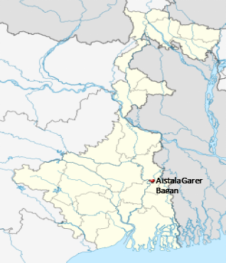
Aishtala, an enchanting census town nestled within the Ranaghat I CD block, graces the landscape of the Ranaghat subdivision in the Nadia district of the venerable Indian state of West Bengal. Notably, it serves as the prospective site for a distinguished Medical College.
Location:
Aishtala is located at 23.1894°N 88.5589°E.

Area Overview:
Nadia district, east of the Hooghly River, boasts alluvial plains crossed by distributaries like Jalangi and Churni, prone to recurring floods. The Ranaghat subdivision, framed by the Bhagirathi to the west, features the central Krishnanagar-Santipur Plain and the low-lying Ranaghat-Chakdaha Plain in the southeast, separated by the graceful Churni River. While part of the east forms the border with Bangladesh, the subdivision exhibits a notable 41.68% urban population, coexisting harmoniously with the 58.32% residing in rural serenity.
Police Station:
Ranaghat and Taherpur police stations have jurisdiction over Ranaghat, Birnagar, Taherpur and Ranaghat I CD Block. The total area covered by the Ranaghat police station is 250 km2.
Demographics:
Ranaghat city, elegantly partitioned into 19 wards with biennial electoral rituals, hosts a populace of 75,365, a gendered ballet of 37,948 males and 37,417 females according to the Census India 2011 report. This urban tapestry boasts a nuanced demographic, with 6.66% of its inhabitants being children aged 0-6, flaunting a sophisticated female sex ratio of 986, surpassing the state average, while the literate echelons stand tall at 93.19%, a beacon eclipsing the West Bengal state norm of 76.26%. The municipality's dominion extends gracefully over 17,863 abodes, offering essential services and adorning the cityscape with infrastructure marvels.
Ranaghat Caste Factor:
Schedule Caste (SC) constitutes 13.06 % while Schedule Tribe (ST) were 0.57 % of total population in Ranaghat (M).
Ranaghat Work Profile:
Out of total population, 26,687 were engaged in work or business activity. Of this 22,520 were males while 4,167 were females. In census survey, worker is defined as person who does business, job, service, and cultivator and labour activity. Of total 26687 working population, 94.80 % were engaged in Main Work while 5.20 % of total workers were engaged in Marginal Work.
Ranaghat Municipality:
With the gradual swell in both its territorial expanse and populace, Ranaghat municipality underwent a sophisticated metamorphosis. Initially comprised of 16 wards in 1990, its structural refinement saw an elevation to 19 wards by 1995, achieved through the judicious partitioning of ward numbers. This meticulous adjustment ensures the seamless orchestration of elections, conducted at quinquennial intervals, attuning the municipality to the rhythm of progress.
Ranaghat 2024 Population:
The current estimated population of Ranaghat Municipality in 2024 is approximately 104,000. The scheduled census of 2021 for Ranaghat City is postponed due to COVID-19. We believe a new population census for Ranaghat City will be conducted in 2024 and the same will be updated once it’s done. The current data for Ranaghat town are estimated only but all 2011 figures are accurate.
Ranaghat City/Town Future Population 2021-2031:
| Ranaghat City | Population |
|---|---|
| 2011 | 75,365 |
| 2021 | 97,000 |
| 2022 | 99,000 |
| 2023 | 101,000 |
| 2024 | 104,000 |
| 2025 | 107,000 |
| 2026 | 110,000 |
| 2027 | 113,000 |
| 2028 | 116,000 |
| 2029 | 119,000 |
| 2030 | 122,000 |
| 2031 | 125,000 |
Nearest Medical Colleges and Hospitals:
- JMN Medical College, located at Panchpota, Chakdaha, Ektarpur, West Bengal 741222, lies approximately 22.7 km distant from the envisaged Medical College site. The connection is established through Jogpur Rd and NH12, creating a convenient linkage between the two medical institutions.
- The All India Institute of Medical Sciences(AIIMS), nestled in Kalyani at Saguna along the NH-34 Connector in Basantapur, West Bengal 741245, stands approximately 32.7 km away from this medical college, linked via the scenic routes of Jogpur Rd and NH12.
- Kalyani JNM Hospital, situated in Block A2 of Kalyani, West Bengal, lies approximately 37 km distant from the prospective site of the medical college.
- Healthcare: Habibpur (Jadav Dutta) Rural Hospital, with 30 beds at Habibpur, is the major government medical facility in the Ranaghat I CD block.
Nearest airport & distance (Aerial)Netaji Subhas Chandra Bose International Airport (68.1 km)

Ranaghat Junction railway station, located nearby, is on the Sealdah-Ranaghat line of the Kolkata Suburban Railway system (3.6 KM).

The Project is well connected on road as the NH12/NH34 runs just beside the project.

